


Cook Inlet Coal Fields Co. - Stock Certificate
Inv# MS1316A Stock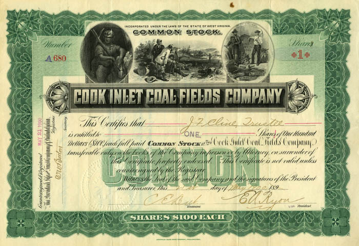
1902-02, Stock. American Bank Note Co., Philadelphia. Superb!! Vignette of surveyors flanked by miner with pick and the state of West Virginia seal. Printed by American Bank Note Company.
This company was near Homer, Alaska. Homer was a small coal town built on Coal Point, at the end of the Homer Spit. In 1896, Homer Pennock and the Alaska Gold Mining Company established a camp at Coal Point, and named it ‘Homer’. By 1899, the Cook Inlet Coal Fields Company had built a company town there, as well as a railway along the Spit to carry coal from mines on the bluff to Coal Point, where ships were loaded. (From: www.coaltowncoffee.com) The Cook Inlet Coal Fields Company founded the town of Homer on the Spit and operated a 7.38-mile-long, narrow, gauge railroad between the Spit and the coal fields near Coal Creek. From 1899 to 1902, the Cook Inlet Coal Fields Company, in the town of Homer, operated on the tip of the Spit (Klein 1987). Bankruptcy papers, filed in 1905, show that the company holdings in Homer included horses, pigs, chickens, and a bull (Miller et al. 1905). In October 1883, the Augustine Volcano erupted and generated a severe earthquake that was felt throughout south central Alaska. A tsunami raced across Lower Cook Inlet, flooded the villages of Port Graham and Nanwalek (Davis and Echols 1962). It also undoubtedly inundated Homer Spit (Waller and Stanley 1966). (From Homer Spit Pictorial History)
Cook Inlet (Tanaina: Tikahtnu; Sugpiaq: Cungaaciq) stretches 180 miles (290 km) from the Gulf of Alaska to Anchorage in south-central Alaska. Cook Inlet branches into the Knik Arm and Turnagain Arm at its northern end, almost surrounding Anchorage. On its southern end, it merges with Shelikof Strait, Stevenson Entrance, Kennedy Entrance and Chugach Passage.
The Cook Inlet watershed is the most populated watershed in Alaska. The watershed covers about 100,000 km2 (39,000 sq mi) of southern Alaska, east of the Aleutian Range, south and east of the Alaska Range, receiving water from its tributaries, the Knik River, the Little Susitna River, and the Susitna and Matanuska rivers. The watershed includes the drainage areas of Denali (formerly named Mount McKinley). Within the watershed there are several national parks and the active volcano Mount Redoubt, along with three other historically active volcanoes. Cook Inlet provides navigable access to the port of Anchorage at the northern end, and to the smaller Homer port further south. Before the growth of Anchorage, Knik was the destination for most marine traffic in upper Cook Inlet. Approximately 400,000 people live within the Cook Inlet watershed.
The inlet was first explored and settled by Dena'ina people. In the 18th century, Russian fur hunters (promyshlenniki) were among the first European visitors. The Lebedev Lastochkin Company leader Stepan Zaikov established a post at the mouth of the Kenai River, Fort Nikolaev, in 1786. These fur trappers used Siberian Native and Alaska Native people, particularly Aleuts from the Aleutian Islands and Koniag natives from Kodiak, to hunt for sea otters and other marine mammal species for trade with China via Russia's then-exclusive inland port of trade at Kiakhta.
Other Europeans to visit Cook Inlet include the 1778 expedition of James Cook, its namesake, who sailed into it while searching for the Northwest Passage. Cook received maps of Alaska, the Aleutians, and Kamchatka during a visit with Russian fur trader Gerasim Izmailov in Unalaska, and combined these maps with those of his expedition to create the first Mercator projection of the North Pacific. The inlet was named after Cook in 1794 by George Vancouver, who had served under Cook in 1778. Turnagain Arm was named by William Bligh of HMS Bounty fame. Bligh served as Cook's Sailing Master on his 3rd and final voyage, the aim of which was discovery of the Northwest Passage.
Upon reaching the head of Cook Inlet, Bligh was of the opinion that both Knik Arm and Turnagain Arm were the mouths of rivers and not the opening to the Northwest Passage. Under Cook's orders Bligh organized a party to travel up Knik Arm, which quickly returned to report Knik Arm indeed led only to a river.
Afterwards a second party was dispatched up Turnagain Arm and it too returned to report only a river lay ahead. As a result of this frustration the second body of water was given the disingenuous name "Turn Again". Early maps label Turnagain Arm as the "Turnagain River".
The S.S. Farallon was a wooden Alaskan Steamship Company liner that struck Black Reef in the Cook Inlet on January 5, 1910. All thirty-eight men on board survived, and were rescued twenty-nine days later. Few white people visited upper Cook Inlet until construction of the Alaska Railroad along the eastern shores of Turnagain Arm and Knik Arm of Cook Inlet around 1915. The natives of the Eklutna village are the descendants of the residents of eight native villages around upper Cook Inlet.
During the 1964 Alaska earthquake, areas around the head of Turnagain Arm near Girdwood and Portage dropped as much as 8 feet (2.4 m) by subsidence and subsequent tidal action. Both hamlets were destroyed. Girdwood was later relocated inland and Portage was abandoned. About 20 miles (32 km) of the Seward Highway sank below the high-water mark of Turnagain Arm; the highway and its bridges were raised and rebuilt in 1964–66.
A stock certificate is issued by businesses, usually companies. A stock is part of the permanent finance of a business. Normally, they are never repaid, and the investor can recover his/her money only by selling to another investor. Most stocks, or also called shares, earn dividends, at the business's discretion, depending on how well it has traded. A stockholder or shareholder is a part-owner of the business that issued the stock certificates.


Ebay ID: labarre_galleries